MENUS

Rabu, 12 Desember 2012

Digitized map of Yogyakarta, INDONESIA Special Region Using ArcView GIS 3.3


"Digitized map of Yogyakarta (INDONESIA) Special Region Using ArcView GIS 3.3"


Understanding Digitizing Maps
Digitization can be generally defined as the process of converting analog data into digital format. Objects such as roads, houses, fields and others earlier in raster format at a high resolution satellite imagery can be converted into digital format by the digitization process.

      Digitizing methods
The process of digitization is generally divided into two types:
1. Digitized using a digitizer.
In the process of digitization requires a digitizing table or digitizer.
2. Onscreen digitizing on the screen.
The most frequent onscreen digitization because it is easier to do, not memerlukantambahan other equipment, and it is easier to be corrected if an error occurs.


Steps - steps to make Digitizing Geographic Information Systems using ArcView GIS 3.3.

1. Make sure that your computer is too ArcView GIS software to install 3.
2. Next, download the file EXT32 complete with additional attributes - new attributes. Once downloaded, copy the file to the Program Files EXT32> ESRI> AV_GIS30> ArcView> EXT32.
3. Copy and Replace the file EXT32.
4. The next step is to open the application ArcView 3.3


5. Enable Extension. How select File menu> Extensions. Then check the menu JPEG, Edit Tool 3.1, and a timer.


6. Create a new project, how to select the menu File> New Project
7. Then paste Jogja.jpg map. I click menu view, then on the menu bar click Add Theme. Then look at each directory - respectively. Do not forget!!! in the lower left corner to change the Data Source Type Image Data Source. Once selected then his appearance would be like below.


8. Then make a new Themes. How select the View> New Theme> Select Line.
If you've selected the overtone aka Line menu at the top left corner. Do not forget to save in advance.


 9. Then create a whole line to mark the colored parts of the map using the "Open Stream Digitize Form"


 10. After that detection and repair line / Line using ET "Edit Tool". How Click the ET> Themes and select Edit.
   11. Then will come the bar ET polyline> Clean> Intersect. When finished click the Analyze menu. It will appear a few red dots.


12. Then correct the line / Line are still red using the Edit Polyline Tools. Previous close bar first. Will appear ET polyline> Start Editing> Show Edit Tools.


13. Edit Using Polyline Edit Tools to analyze and perform all the red dots disappear.


14. Build Polygons
      Cleans out of the bar and did Stop Editing> Yes and save.
15. Select the Build Polygons to bar ET polyline> Apply 2 times Save> OK.
16. After That would Appears Bar "Polyline To Polygon"> Select NO and the results are as shown in the following.


Scope of Geographic Information Systems (GIS)

Scope of Geographic Information Systems 
Geographic Information Systems (GIS)
Geographic Information System is a system of hardware, software, and procedures designed to obtain, process, manipulate, analyze, demonstrate, and display spatial data to solve complex planning, processing, and researching issues. In other words, GIS is a computer-based information system that combines elements of maps (geographic) and information about the map (data attributes). Thus, GIS is a computer system which has the following four capabilities in handling the data referenced geography:
(A) input, (b) data management (storage and retrieval), (c) the analysis and manipulation of data, (d) output.

     Geographic Information System Components
Components of GIS support consists of five integrated components that work in the hardware (hardware), software (software), data, people, and methods that can be described as follows:

    Hardware (hardware)
    SIG Hardware is the physical devices that are part of the computer system that supports the analysis and mapping goegrafi. GIS hardware has the ability to present images with high resolution and speed, and supports database operasioperasi with large volumes of data quickly. GIS hardware consists of several parts to enter the data, process the data, and print the results of the process. Here's division by the process:
    Input data: mouse, digitizer, scanner
    Imaging data: hard drive, processor, RAM, VGA Card
    Output data: plotter, printer, screening.

    Software (software)
    The software used to carry out the process of storing, analyzing, visualizing data both spatial and non-spatial. The software must be in the GIS software components are:
        Tool to insert and manipulate GIS data
        Data Base Management System (DBMS)
        Tool to analyze data
        Tools for data display and analysis

    Data
    In principle there are two types of data to support the GIS are:
        Spatial Data
        Spatial data is a real picture of a region that is on the earth's surface. Generally represented in the form of graphs, maps, pictures with a digital format and stored in the form of the coordinates x, y (vector) or in the form of images (raster) that have a certain value.
        Non-Spatial Data (Attributes)
        Non-spatial data is in the form of data tables where the table contains information possessed by objects in the spatial data. The data form an integrated tabular data with spatial data available.
    Human
    Humans are the core elements of the SIG because humans are planners and users of GIS. Users SIG has a degree as in other information systems, from the level of technical specialists who design and manage the system to the users who use GIS to assist day-to-day work.
    Method
    The method used in GIS will be different for each problem. SIG is good depending on the design aspects and aspects of Real side.

     Scope of Geographic Information Systems
Basically there are six processes in GIS are:

1. Input Data
          Process input data is used to input data spatial and non-spatial Data. Spatial data is usually in the form of analog maps. For GIS to use digital map so that the map must be converted to analog in the form of a digital map using a digitizer device. In addition to digitizing process can also be done by the overlay on the map analog scanning process.

2. Data Manipulation
          Type of data required by a part SIG may need to be manipulated to fit the system used. It is therefore able to perform editing functions of GIS for spatial data and non-spatial.

3. Data Management
          Once spatial data is inserted the next process is non-spatial data processing. Pengolaha the data include the use of non-spatial DBMS to store data that has a large size.

4. Query and Analysis
          Query is the tabular analysis is done. Fundamentally GIS can perform two types of analysis, namely:
a. Proximity Analysis
          Proximity analysis is based on the analysis of the geographical distance between the layers. GIS uses buffering process (building a supporting layer around within a certain layer) to determine the nature of the close relationship between the existing sections.
b. Overlay Analysis
          Overlay is the process of pooling data from different layers layers. In simple overlay called visual operations that require more than one layer to be combined physically.

5. Visualization
          For some types of geographic operations, the best outcome is realized in a map or graph. Map is very effective for storing and delivering geographic information.

source: http://id.wikipedia.org

Geographic Information System (GIS)


          Geographic Information System (GIS) is an information system designed to work with spatially referenced data or berkoordinat geography or in other words, a GIS is a database system with specific capabilities for spatially referenced data handling ( spatial) working in conjunction with a set of operations (Barus and Wiradisastra, 2000).

        Meanwhile, according to Anon (2001) geographic information system is an information system that can combine the graphical data (spatial) and text data (attributes) that are connected in geogrfis object on earth (georeference). In addition, GIS can also combine data, organize the data and perform data analysis which ultimately will produce output that can be used as a reference in decision-making on issues related to geography.

                        Geographic Information Systems are divided into two groups: manual systems (analog), and automated systems (digital-based computers). The most fundamental difference lies in the way of management. Information systems are usually manually merge some data such as maps, transparencies for overlapping stacking (overlay), aerial photography, statistical reports and reports of field surveys. All of the data is compiled and analyzed manually with a tool without a computer. While automated Geographic Information Systems has been using the computer as a data processing system through the process of digitization. The data source can be either digital or satellite imagery and digital aerial photographs were digitized aerial photographs. Other data can be digitized base map (Nurshanti, 1995).

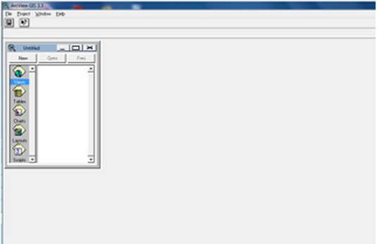
                      Understanding GIS / SIG today is more often applied to the spatial or geographic information technologies oriented to the use of computer technology. In conjunction with computer technology, Arronoff (1989) in Anon (2003) defines GIS as a computer-based system that has the ability to handle data that is referenced geographic data entry, data management (storage and recall), manipulating and analyzing data, as well as the output the final result (output). While Burrough, 1986 defines a Geographic Information System (GIS) as a computer-based system used to enter, store, manage, analyze and re-enable the data that have spatial reference for a variety of purposes related to mapping and planning. The main components of Geographic Information Systems can be divided into 4 main components: hardware (digitizer, scanner, Central Procesing Unit (CPU), hard disk, etc.), software (ArcView, Idrisi, ARC / INFO, ILWIS, MapInfo, etc.), organization (management) and user (user). The correct combination of the four main components will determine the success of a development project Geographic Information Systems.

GIS applications can be used for various purposes for which the data is processed has geographic references, meaning the data is composed of the phenomenon or object that can be presented in a physical form and spatial location (Indrawati, 2002).


The main objective of the use of Geographic Information Systems is to make it easier to get the information that has been processed and stored as an attribute of a location or object. The main characteristic of data that can be used in Geographic Information Systems is the data that has been tied to the location and a basic data that has not been specified (Dulbahri, 1993).

The data are processed in GIS is basically composed of spatial data and attribute data in digital form, so that the analysis can be used is the analysis of spatial and attribute analysis. Spatial data is data relating to the spatial location of the general shape of the map. While attribute data is a data table that serves to explain the existence of various objects as spatial data.

The presentation of spatial data has three basic ways, namely in the form of dots, lines and shapes form area (polygon). The point is a single appearance of a pair of x, y coordinates showing the location of an object such as height, location of the city, the location of the sample and the others. The line is a set of points which form an elongated appearance such as rivers, roads, and other kontus. While the appearance of the area is bounded by a line that forms a homogeneous space, for example: boundary, limit the use of land, islands, and so forth.

Spatial data structure divided into two raster data models and data models vector. Raster data is data that is stored in a rectangular box (grid) / cell, forming an orderly space. Vector data is data that is recorded in the form that displays the coordinates of the point, placing and storing spatial data using point, line or area (polygon) (Barus and Wiradisastra, 2000).

Lukman (1993) states that the present geographic information systems spatial information and its attributes which consists of several main components:
1. Input data is the process of entering data on a computer from maps (topographic maps and thematic maps), statistics, data analysis of remote sensing data from remote sensing digital image processing, and others. Spatial data and attribute in the form of analog or digital data is converted into the format required by the software to form the database (the database). By Anon (2003) database is organizing data in a computer so it is not redundant to do the development, renewal, calling, and can be shared by users.
2. Data storage and recall (data storage and retrieval) is the storage and retrieval of data on a computer back quickly (look on the screen and can be displayed / printed on paper).
3. Data manipulation and analysis are activities that can be done a variety of commands such as map overlay between the two themes, create a buffer zone a certain distance of an area or a point and so on. Anon (2003) says that the manipulation and analysis of data is a major feature of the SIG. GIS capabilities in a joint analysis of spatial data and attribute data will yield useful information for a variety of applications
4. Data reporting is to present the basic data, the data processing of the data from the model into the form of maps or tabular data. According Barus and wiradisastra (2000) form a GIS product may vary both in terms of quality, accuracy and ease of the wearer. These results can be made in the form of maps, tables figures: text on paper or other media (hard copy), or in the print software (such as an electronic file).
By Anon (2003) there are several reasons why it is necessary to use GIS, such as:
1. GIS spatial data and attribute using an integrated
2. GIS can digunakansebagai interesting interactive tools in order to increase the understanding of the concept of location, space, demographic and geographic elements that exist on the surface of the earth.
3. GIS can separate the presentation and database
4. GIS has the ability to decipher the elements that exist on the surface of the earth into several layers or spatial data coverage
5. SIG has an excellent Traffic in visualizing spatial data following attributes
6. All operations can be performed in an interactive GIS
7. Results were obtained with a simple GIS thematic maps
8. all GIS operations can costumize by using the commands in the scripting language.
9. Peragkat GIS software provides the facility to communicate with other software
10. GIS greatly assist the work that is closely related to the field of spatial and geoinformatika.


Barus and Wiradisastra (2000) also revealed that GIS is a powerful tool for handling spatial data, which the GIS Data maintained in digital form so that the data is more compact than in the form of printed maps, tables or any other conventional form that will eventually speed up the work and alleviate the costs.
Primary means for handling spatial data is GIS. GIS is designed to accept large amounts of spatial data from various sources and mengintergrasikannya become an informed, one type of data is the remote sensing data. Remote sensing has the ability to produce spatial data geometric arrangement of the actual state approaching quickly and in large quantities. Barus and Wiradisastra (2000) said that the SIG will provide added value to the remote sensing capability to produce large spatial data where the utilization of remote sensing data depends on the handling and processing of data which will turn it into useful information.


Currently, GIS is berbgai diapliksikan in areas such as agriculture, environment, natural resource management sumbur, tourism, geology, planning and so forth. Why is used by SIG excellence in these areas is the ability to integrate the spatial data and attribute data so that the analysis of complex information capable of excellent results were obtained. In addition to these capabilities is a result of the time savings Apliksi SIG.
Apliakasi GIS in the planning process very diverse forms depending on user needs. Anon (2003) says that the point of application of GIS is suspected of various activities undertaken such as monitoring pollution, changes in land use or a development plan. Taken as an example is a plan to build irrigation systems and dams. If a dam is built diloksi particular, it can be developed in several follow-up question is how to make variations of the structure or form and analyzed how the effect or other scenarios that could be developed such as those associated with the age of the dam itself.

In general, to get answers from the information available, we need a framework of good questions. Barus and Wiradisastra (2000) provide an illustration of the system framework menganai need answers about possible dangers and management sector in urban areas.

1. The presentation of all the data available to target specific answers such as databases on public roads or existing facilities
2. data pattern should be visible, such as the value of a particular region in land prices
3. predictions about the data or the results associated with a different time and place. For example estimate occurrence of natural disasters, it is important to know to make possible emergency scenarios.
To get the answers to the above, it is necessary to recognize the characteristics of the data needed regarding specific questions, namely:
1. data types that are available, how its shape? For example, in data Cadastral hence the name and address of the owner of the house or the land need to know
2. how the pattern of the data? This question is asking for information related to the pattern of the spread of certain valuable as houses. So if all the data are presented all at once, the necessary information such as homes that have sold more expensive than the value of USD 100 million will be immediately visible
3. data can be modified into any kind? This question is important to develop the desired model. The model can be made as simple as suspect crop production this year with an analysis based on data from last year and this year. But this model can also be more complicated example to predict changes in river flow downstream in the event of changes in the forest in the upper watershed.

Of the question that the necessary functions are functions of the storage and retrieval, the selection function is limited and modeling functions. These three functions will be modeled to explore the way to have the main areas, settlements worth more than $ 100 million and, determining the optimal path for the relief channel.
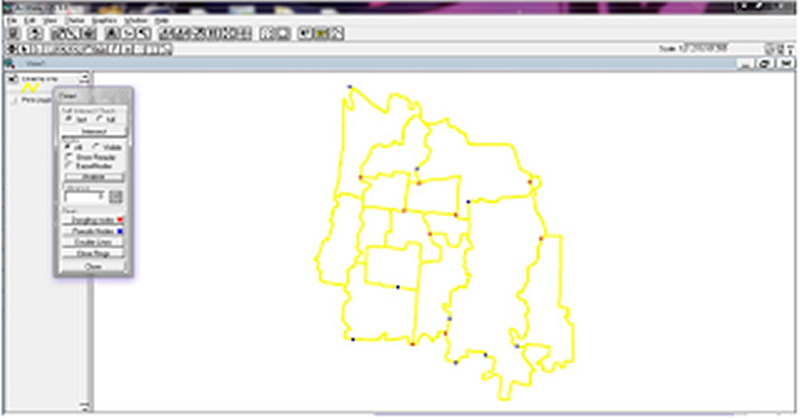
Senin, 02 Mei 2011

Osama bin Laden (Al-Qaida terrorist organization) killed in Pakistan, "Obama says"

Source : NBC News and msnbc.com

HOT NEWS

          Osama bin Laden, the Saudi extremist whose al-Qaida terrorist organization killed more than 3,000 people in coordinated attacks on the U.S. on Sept. 11, 2001, is dead following a military operation in Pakistan and the U.S. has recovered his body, U.S. President Barack Obama announced Sunday night.
"Justice has been done," the president declared as crowds formed outside the White House to celebrate, singing "The Star-Spangled Banner" and "We Are the Champions," NBC News reported.

          Obama said bin Laden, whom he called a terrorist "responsible for the murder of thousands of American men, women and children," was killed in Pakistan earlier in the day after a firefight in a military operation that was based on U.S. intelligence. Other U.S. officials said one of bin Laden's sons and two of his most trusted couriers also were killed, as was an unidentified woman when she was used as a human shield.
Charles Wolf of New York, whose wife, Katherine, died on Sept, 11, 2001, rejoiced at the news, which he called "wonderful."
"I am really glad that man's evil is off this earth forever," Wolf said. "I am just very glad that they got him."

           Former President George W. Bush said in a statement that he had personally been informed by Obama of the death of the terrorist leader whose attacks forever defined his eight years in office.
"This momentous achievement marks a victory for America, for people who seek peace around the world, and for all those who lost loved ones on September 11, 2001," the former president said.
"The fight against terror goes on, but tonight America has sent an unmistakable message: No matter how long it takes, justice will be done."

          Obama echoed his predecessor, declaring that "the death of bin Laden marks the most significant achievement to date in our nation's struggle to defeat al-Qaida."
But he stressed that the effort against the organization continues. Al-Qaida remains in existence as an organization, presumably under the leadership of Ayman al-Zawahiri, 59, an Egyptian physician who is widely believed to have been bin Laden's No. 2.

Who is Ayman al-Zawahiri?
"We must and we will remain vigilant at home and abroad," he said, while emphasizing that "the United States is not and never will be at war with Islam."
Bin Laden shot in the head, U.S. says 

        Officials had long believed that bin Laden was hiding a mountainous region along the Pakistan-Afghanistan border. In August, U.S. intelligence officials got a tip on his whereabouts, which led to the operation that culminated Sunday, Obama said.

          U.S. officials told NBC News that U.S. Special Operations forces carried out the attack on the al-Qaida compound, killing bin Laden when they shot him in the head during a firefight.
The special operations forces returned with the body to Afghanistan, U.S. officials said. They said they were ensuring that it was being handled in accordance with Islamic practice and tradition.
"We take this very seriously. This is being handled in an appropriate manner," one said.
Senior administration officials said U.S. officials believed they had known where bin Laden was since September. By mid-February, information developed that made them confident that the information was sound.

In mid-March, Obama headed five National Security Council meetings on the subject. Friday morning, he gave the final order to carry out the attack on a compound in what was described as an "affluent suburb" of Islamabad.

"The bottom line of our collection and analysis was that we had high confidence that the compound held a high-value terrorist target," a senior official said, with a "strong probability" that it was bin Laden.
Bin Laden's compound was huge and "extraordinarily unique," about eight times larger than other homes in the area, U.S. officials said.

They said the compound was isolated by 12-foot walls, with access restricted to two security gates. It had no telephone or Internet service and had clearly been custom built to hide "someone of significance."

U.S. intelligence officers concluded that bin Laden was probably there with his youngest wife. "No other candidate fit the bill as well as bin Laden did," one of the U.S. officials said.

Jumat, 08 April 2011

Alien Shooter 2 [Game PC] free

Alien Shooter 2 Ngablu.com

Alien.Shooter.2.Conscription.Cracked-THETA | 615MB

Published by : Sigma Team | Developed by : Sigma Team
Release Date : 2010/07/05
Genre : Arcade, Shooter, Isometric, Standalone
Language : English

DOWNLOAD LINK :
http://www.mediafire.com/?4x33de3pbbqsj
Password :
bendol-online
Password Rar :
www.arab-gb.com

INFORMATION :

Game features:
* The enemy of the people, more than 100 zombies on one map at a time.
* The ability to upgrade the main character parameters.
* More than 60 types of weapons, including sniper rifles.
* Many enhancements, including radar and combat aircraft.
* Some type of vehicle to drive.
* Three types of games: Campaign, Survive, Stand Gun.

System requirements:
* Operating System: Windows XP / Vista / 7
* Processor: Intel Pentium IV 2,4 GHz, AMD Athlon 2800 +
* Memory: 1 GB of RAM
* Graphic: nVidia GeForce FX 5700, ATI Radeon 9600 or better video card with 128 MB
* Sound Card: Sound device compatible with DirectX ® 9.0
* Hard Disk Space: 1.5 GB available

Tron Evolution RELOADED 2010 [Game PC] free

Tron Evolution RELOADED Ngablu.com

Tron Evolution RELOADED 2010 | 7GB


DOWNLOAD LINK :
Password : world4free.in

INFORMASI :

Minimum System Requirements:
1. Operating system: Windows XP/Vista/7 with installed. Net framework 2.0
2. Processor: 1.4 GHz Pentium 4 or equivalent
3. Memory: 512 MB (XP) / 1 GB (Vista / 7)
4. Video: 128 MB DirectX 9 compatible video card (Shader 2.0)
5. Sound: 16 bit DirectX 9 compatible sound card
6. Hard disk space: 6.5 GB.

Japan: Earthquake prompts regional alert

The BBC's Roland Buerk described how the quake felt in Hanamaki in north-east Japan


A powerful aftershock has struck north-east Japan, a month after a violent quake led to a devastating tsunami.

Officials ordered mass evacuations and workers at the damaged Fukushima nuclear plant took shelter after the quake triggered a tsunami warning.
But the alert was lifted after 90 minutes and no damage was reported at the nuclear plant.

Emergency crews said two people died as an indirect result of the quake and about 100 more were injured. A 63-year-old woman died when the tremor knocked out power in Yamagata prefecture, shutting off her respirator.
And a 79-year-old man in Miyagi prefecture died of shock.
 
'So scared'
The latest earthquake - at a depth of 49km (32 miles) - struck off Japan's north-east coast, close to the epicentre of the 11 March quake.

All seven of the workers at the crippled Fukushima Daiichi nuclear power station were safe, a spokesman for plant operator, Tepco, told a news conference in Tokyo.
"They have not been injured and they have all taken shelter in our seismic-resistant building," he said.

The workers are trying to keep the damaged reactors cool to stop further releases of radioactive material.
Thursday's quake struck at 2332 local time (1432 GMT) on Thursday, 118km (78 miles) north of Fukushima, 40km offshore.
First reports said it had a magnitude of 7.4 but that was later revised to 7.1, according to the US Geological Survey (USGS).
Last month's earthquake had a magnitude of 9.0 and struck at 32km deep.
Thursday's quake struck at about the same location as the 11 March quake.

The quake was strong enough to shake buildings in Tokyo, 265km to the south.
"It started off with small shakes, then shook bigger," Miri Gono in Tokyo told the BBC by e-mail.

"I was alone in my house with my brother and we were so scared... We took our bottles of water and hid under the table."
Japan's meteorological agency issued tsunami warnings and advisories for a stretch of coast 420km long, from Aomori prefecture in the north to Ibaraki prefecture in central Japan, just north of Tokyo.

Hundreds of aftershocks have shaken north-eastern Japan in the wake of the earlier earthquake, but few have measured higher than 7.0.
About 28,000 people are dead or missing, and hundreds of thousands were left homeless after the tsunami which ripped through the region.
 
source: bbc.co.uk


Tools - Backup Blog

Backup Blog Tools Ngablu.com 

Hot Issue : Backup Blog Tools | 1MB


    Google is currently doing a massive raid on a blog that provides stall-stall vcd / dvd bootleg on bloggers, many who have become victims. Therefore for those of you  who also create a blog warez and fear got banned from GOOGLE. please backup your blog database using this application.
 

DOWNLOAD LINK :
http://www.enterupload.com/iqit31t5euc3


Blog "Warez" Closed Google (BANNED)

Blog Warez Ditutup google Ngablu.com 


    For those of you who like to surf the Internet and download the  movie  would  like to  know some blogs that provide free movie that are managed by local actors  such as  TheHack3r.com  or Cinema3satu.blogspot.com. Currently free movie provider site  has been  closed  by the bloggers in this case google.

    When we tried to visit a blog address or Cinema3satu.blogspot.com TheHack3r.com it will instantly appear a message stating the blog in question was deleted. And here are the messages that appear when you visit a blog address or cinema3satu.com TheHack3r.com.

   Blog has been removed
Sorry, the blog in cinema3satu.blogspot.com has been deleted. This address is not available for new blogs.
What should your blog be here? Read: 'I can not find my blog on the Web, so there is where? "

   There were rumors circulating in some forums, that the closing of the blog because TheHack3r.com and Cinema3satu.blogspot.com removed by the bloggers because they have violated the terms of the Blogger service. Not only local but Blogger Blogger out too much to be removed like any other warez 300mkv.blogspot.com and bloggers.

   It may be used as material for reflection blogger friend that is currently providing illegal content, should now backup the database on your blogger and when getting banned from google, then you can create new blogs with different names but with the same content.

     Currently it is on closing the blog google warez / illegal without prior notification, there is currently no further information about the purpose of google do this.
But now you need not worry too much. You can still download the latest movies or local hollywood on this website. So feel free to.

Source: Ngablu.com

Sabtu, 02 April 2011

MiniLyrics 7.0.643 With Keygen

"Mini Lyrics"

MiniLyrics 7.0.643 Ngablu.com

     Lyrics software displays when the music player is running, as in Winamp, Media Player, AIMP, etc.. On this occasion I give to you MiniLyrics 7.0.643 which is the latest version of MiniLyrics. For those of you who do not know about this software please read HERE. In many versions of this tebaru these features that make you more comfortable, such as the display text or background can be changed and this latest version looks more friendly than previous versions. For more details you can visit the original site HERE.

Naruto Ngablu.com

Download MiniLyrics 7.0.643 With Keygen